Integrated Water Resource Planning
Integrated Water Resource Management
Integrated Water Resource Management (IWRM) promotes the sustainable and equitable use of water through the coordinated planning of water, land, and other related resources. Coordination between governments and water-related agencies across a region maximizes social and economic benefits without compromising water availability, water quality, or ecosystem health.
IWRM follows the One Water approach, which treats all water - stormwater, groundwater, surface waterways, and wastewater - as an interconnected system.
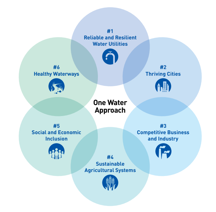
Image Source: US Water Alliance
Region 1 Planning Council's Role
Water is a critical resource to the Rockford Region as it is home to a high volume of surface and subsurface waters, including rivers, lakes, and additional waterways. The escalating impacts of climate change, projected population growth, and regional development may create many challenges for the Rockford Region’s water systems, including flooding, stormwater management issues, depleting water supply, and water quality degradation.
Region 1 Planning Council (R1) promotes regional collaboration on water resources by facilitating coordination and education and providing technical assistance to local governments and organizations on various water resource management initiatives.
R1’s IWRM program will provide the Rockford Region with a hub of water-related information to better understand local water systems, water issues facing the region, and possible solutions.
Water Resources Toolkit
Introduction to Stormwater
Stormwater originates from precipitation such as rainfall or snowmelt. After a precipitation event, some stormwater absorbs into the ground and is naturally filtered before replenishing groundwater aquifers. Other stormwater runs off into water bodies such as rivers or lakes.
The Rockford Region’s stormwater management drain system is separate from wastewater. This infrastructure directs the stormwater into local waterways. Impervious surfaces like pavement cause water to not be able to absorb into the ground, instead running off into bodies of water. Stormwater runoff picks up pollutants such as chemicals, debris, and bacteria before washing into waterways, which raises concerns about contamination and human health risks. Runoff also raises the likelihood of flash floods and flooded bodies of water.
Flooding
Flooding is typically caused by excessive rainfall that causes bodies of water to overflow. The immediate risks of flooding include injury, exposure to pollutants, clean water contamination, and power loss. Long-term, and potentially more notable, effects of flooding are home and property damage, disrupted transportation networks, restricted access to critical resources, and heavy physical and financial burden for cleanup or repair, disproportionately affecting minority or low-income households.
The frequency of flooding events across the region is increasing, with projected rises in annual precipitation indicating this trend will likely continue. Floodplains, areas of low-lying ground adjacent to rivers and streams, are particularly susceptible to flooding.
Resources
Introduction to Wastewater Treatment
Wastewater refers to used water that has been contaminated as a result of human processes such as showering, flushing the toilet, and washing dishes and laundry. This water is treated to remove contaminants before it can be used again.
Wastewater from much of Winnebago County, including Rockford, is treated at Four Rivers Sanitation Authority. Some municipalities in the region, such as the City of Belvidere, have their own wastewater treatment utilities. Rural areas tend to have private septic tanks.
Resources
Introduction to Watershed Planning
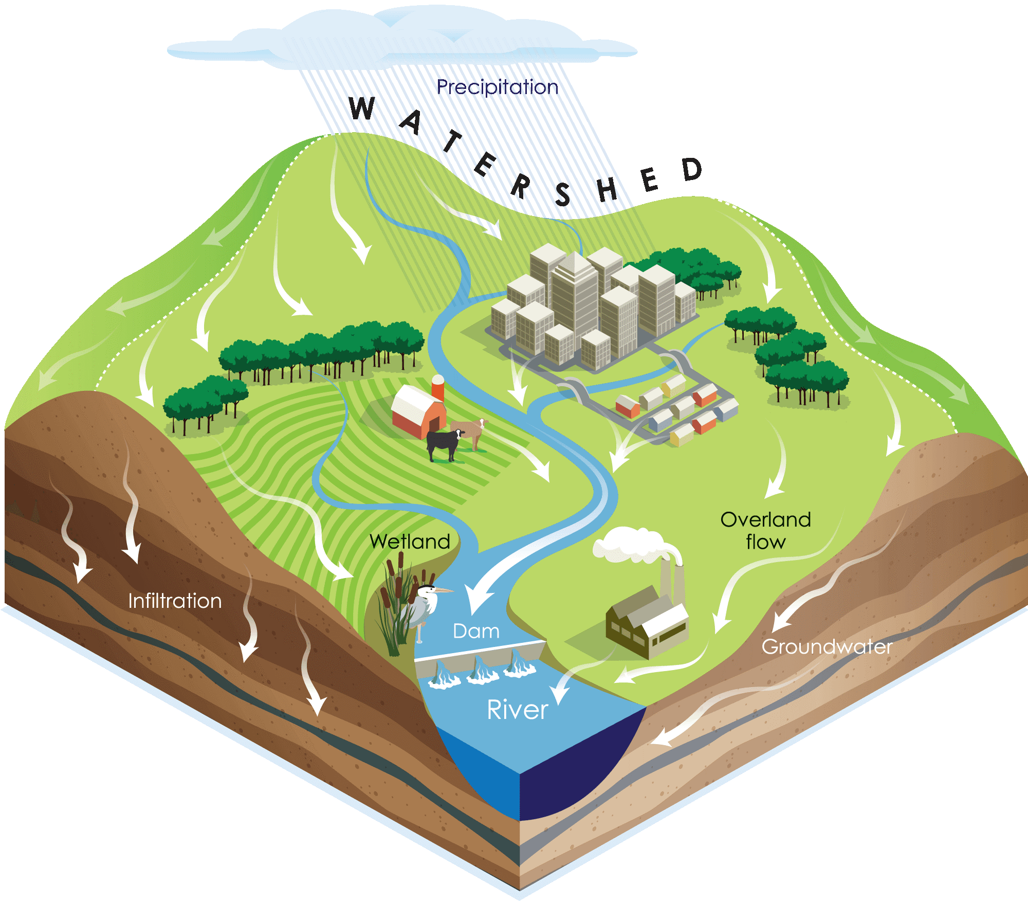
Image source: Berks County Conservation District
A watershed is an area that contains all land that drains into a particular body of water. Watersheds are often used as planning area units for water management. A watershed management plan provides a framework to protect or restore water quality in a given watershed. Of the major watersheds in Illinois, the Rockford Region falls within the Lower Rock River watershed. Within this are smaller watersheds, which can also be used for planning.
R1 has received Section 319 grant funding from the Illinois Environmental Protection Agency to implement bioswales and bioretention basins to protect water quality in the Buckbee Creek and South Fork Kent Creek watersheds. Under the 319 grant, R1 also provides educational outreach about nonpoint source pollution control best management practices.
Surface Water
Together, the region’s waterways and wetlands form a system that feeds into larger water bodies. The quality and quantity of water in the region’s rivers, streams, and lakes sustain ecosystem health and enhance residents’ quality of life. Healthy watersheds provide ecosystem services, economic benefits, and physical health benefits through recreational opportunities for swimming, boating, and fishing.
In the Rockford Region, the Sugar and Kishwaukee Rivers are biologically significant streams hosting rich fish and mussel populations. Tributaries to the region’s rivers provide high-quality habitat for many aquatic species. Watershed planning identifies ways to improve ecosystem health for these species and supports the watershed’s ecosystem services, such as nutrient cycling, carbon storage, biodiversity, and flood control.
Resources
Introduction to Water Supply
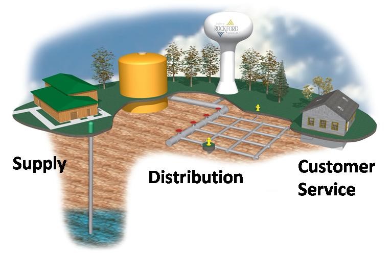
Image source: City of Rockford
Water supply is all of the available water for industrial, community, or individual use. The Rockford Region has plentiful groundwater aquifers, sourcing all its drinking water from groundwater. Groundwater is found underground between cracks, soil, sand, and rock, typically identified in permeable spaces called aquifers. Threats to groundwater include depletion and contamination.
The region has no central treatment plant - water is treated at each well before distribution. While municipal water supply does not source from surface water, such as the Rock River, some industrial processes may use surface water to fill their water demand.
With a changing demand for water supply from projected population growth, climate change impacts, and industrial expansion, water demand may outpace supply. Climate change alone is projected to increase regional water usage by over eight percent.
Drinking Water Quality
Drinking water includes the water systems and infrastructure that supply drinking water, including the groundwater supply. Groundwater stressors may cause drinking water quality to decrease. The most common contaminants found in groundwater in the Rockford Region include chloride from road salt, nitrate from agricultural activity, and chemicals from industrial and human activities.
Resources
- Rock River Region Water Demand
- ISWS Water Supply Planning for the Rockford Region
- ISWS Water Quality in the Rock River Region
- ISWS Rock River Region Water Supply Planning
- ISWS & IDNR 2023 Report on Water Supply Planning for the Rock River Region
- City of Rockford Water System
- City of Rockford Lead Service Line Replacement Program